Peaks of the Icefields Parkway – Part 3
“A new world was spread at our feet; to the westward stretched a vast icefield probably never before seen by the human eye, and surrounded by entirely unknown, unnamed, and unclimbed peaks.”
J Norman Collie, 1898
It may be hard to imagine now, but the Columbia Icefield and surrounding peaks have only become accessible within the last century. When J Norman Collie and his climbing companion Hermann Woolley viewed the icefield from the summit of Mount Athabasca in 1898, it was like discovering a whole new world. The area was remote and difficult to reach. There were no roads and no railroads. Fur trade routes and First Nations trails were to the north and to the south. The icefield was in no-man’s land. It’s no wonder Collie believed he and Woolley were first to view the awe-inspiring icefields in 1898.
Since that time, the area has opened to adventurers and explorers and most peaks now have names. Some, in fact, have had several names. This list tells the stories behind the naming of some of the most significant peaks and geographical features along the Icefields Parkway.
Huge thanks to Dave Birrel of www.peakfinder.com for allowing us to borrow content from his amazing website. Please visit this website to find out everything you’d want to know about almost all the Mountains in the Rockies.
This is Part 3 in a series of 6 posts which all together will cover 60 of the most scenic and interesting mountain peaks that you’ll ride past during the tour. Enjoy!
1. Sunwapta Pass, 2027 m (6650 ft)
After lunch you’ll have just one last gentle climb up and over Sunwapta Pass before an exhilarating descent down the other side.
Sunwapta Pass is one of two high passes that we’ll cross during the tour and it marks the boundary between Banff and Jasper National Parks. The waters from its summit flow south to the Saskatchewan River and north to the Athabasca River.
It was a significant barrier to the first explorers. Once crossed though the Columbia Icefields and all the peaks that we’ve been riding through eventually got explored and climbed and we now get to access this area easily and take in the beauty from our bikes. It’s quite humbling to imagine what it took to visit this area over 120 years ago.
“The country here was much more open and the going perfectly easy. Our course lay W.N.W.; and, passing through some pretty park like glades, the outfit emerged into a broad, green, and nearly level valley. We had passed the watershed unawares; for the tiny rivulet that now meandered, parallel with us, peacefully through the meadows was the infant Athabasca starting on its long journey to the Great Slave Lake and the Arctic Ocean.” Norman Collie and his party had just arrived at Sunwapta Pass and were about to be the first to see and explore the Columbia Icefields that lay hidden above them. Although the Icefields Parkway winds its way through the pass, much of the area remains as Collie saw it over one hundred years ago.
From the pass, the highway travels through Collie’s “broad, green, and near level valley” for five kilometres. These meadows are at an elevation of over two thousand metres, beautiful on many days in summer, but often windswept, cold, and barren during the winter
In 1896 Walter Wilcox, Robert L. Barrett, and guides Tom Lusk and Fred Stephens travelled north over Bow Pass, up the Saskatchewan River and became the first to reach Sunwapta Pass. They were on a sixty day expedition and searching for a pass through which to reach the Athabasca River. Impressed by, “the tremendous grandeur of mountain scenery,” the group explored the area, Barrett even attempting to climb, “a beautiful, glacier-hung peak” which must have been Mount Athabasca.
In order to determine if the party could continue over the newly discovered pass, Fred Stephens was able to pass between the toe of the Athabasca Glacier and the steep slopes of Mount Wilcox but found that, “the route which first appeared most promising was blocked by a canyon.” The party then proceeded over a high grassy pass to the east of what is now known as Mount Wilcox, descending into the Sunwapta Valley beyond Tangle Falls and the steep canyon to continue their explorations. The pass was later named in honour of Walter Wilcox.

2. Cirrus Mountain (Named in 1935) 3270m (10729ft.)
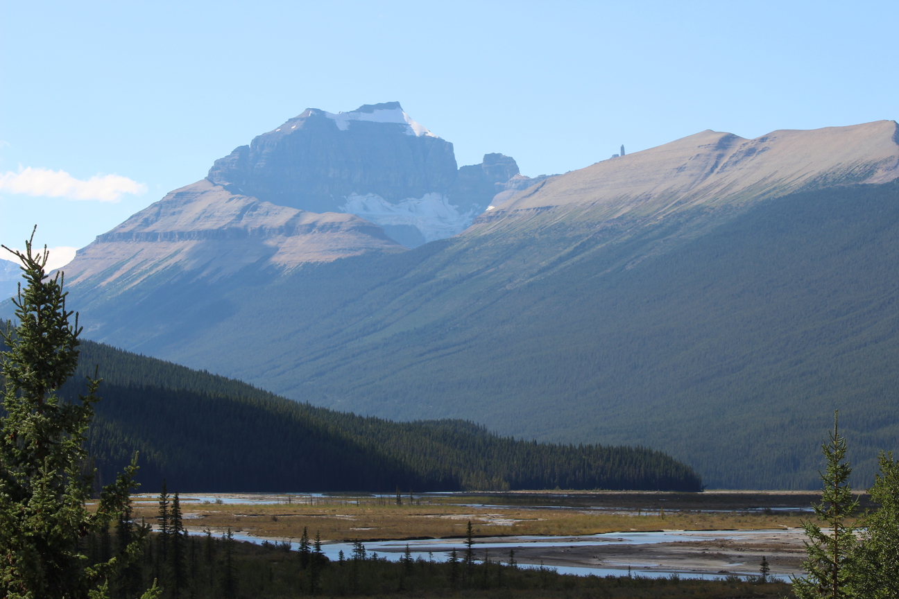
As you descend 15km down the other side of Sunwapta Pass an amazing sight will appear in front of you. An awesome view down the north Saskatchewan Valley, which is a gigantic U-shaped canyon sandwiched between Cirrus Mountain on the left and the northeast ramparts of Mount Saskatchewan on the right. The cliffs in the top and bottom of Cirrus are composed of massive limestone, while the gentle sweeping talus slopes halfway to the summit, are formed of easily weathered shale.
The Icefield Parkway is so close to this high mountain that the summit cannot be seen as one travels along its base. However the steep cliffs of the “Weeping Wall” may be seen with numerous slender waterfalls spilling down the cliffs. This is a favourite spot for ice climbers during the winter months when spectacular pillars and curtains of ice form.
We’ll stop at the base of the Weeping Wall to regroup after the long descent and to take in the views for a bit.
Cirrus Mountain is named for the thin, wispy clouds that form at altitudes over 20 000 feet (6000 metres).


3. Mount Saskatchewan (Named in 1898), 3342m (10965ft.)
After regrouping at The weeping wall you’ll have just 30km’s of rolling hills to go till the end of the day. Shortly after leaving the weeping wall, look to your right for views of Mt Saskatchewan.
Mount Saskatchewan’s name is derived from its position near the headwaters of the Saskatchewan River. The upper cliffs of its southern face which we see from Alexandra River Flats, are almost always covered with snow. Its northern slopes features a large glacier.
In his book, “The Glittering Mountains of Canada,” J. Monroe Thorington summed up appearance of Mount Saskatchewan to those travelling up the valley north of Saskatchewan River Crossing as follows, “Filling the great angle between Alexandra River and the North Fork, a thing of towers and battlements, rises Mount Saskatchewan. Formidable in appearance, and long sought by climbers, it had never failed to attract the attention of those who came into the region. A symmetrical monolith on the jagged northeast ridge is well known as the ‘Lighthouse’ and serves as a landmark in the valley of the North Saskatchewan.”
J. Monroe Thorington was a prominent mountaineer in the 1920’s and 1930’s and completed fifty two first ascents in the Rockies and Selkirks. He definitely had his eye on this peak when he rode up the valley in 1923. “We knew the mountain well by this time. From the east, on the slopes of Mount Coleman, we had gazed upon its unclimbed heights, wondering at its sheer forbidding face of snow-powdered cliff.” With guide Conrad Kain and W.S. Ladd, Thorington completed the first ascent of this challenging peak and was, “satisfied beyond expression that we had been the first to ascend a mountain whose impressive and imposing architecture had for years excited our admiration.”
The northern cliffs and glaciers of Mount Saskatchewan may be seen from the roadside part way up the steep hill on the south side of Sunwapta Pass.
The spectacular pinnacle known as Lighthouse Tower, or as it is sometimes called “Cleopatra’s Needle,” rises over 75 metres from a ridge which extends to the east of the highest part of Mount Saskatchewan. It may be seen from a pull-off 4.9 kilometres to the south of the Alexandra River Flats Viewpoint and this is also the best spot for a view of Mount Saskatchewan. Another view of the Tower is through a gap in the ridges 5.2 kilometres north of the viewpoint and although the spire is much closer and still spectacular, it is not nearly as “needle-like” as it is from the south.

4. Mount Coleman (Named in 1898), 3135m (10286ft.)
Mount Coleman is a “helmet shaped” peak which may be seen on the east side of the Icefields Parkway, to the north of Saskatchewan River Crossing and is named after Dr Arthur Coleman, one of the first to explore the area that is now Jasper National Park.
Arthur Coleman (1852-1939) was a Professor of Geology at the University of Toronto who travelled widely in the Canadian Rockies and Selkirks. He completed a total of eight trips major trips, all of which were exploratory in nature. His brother, L. Quincy Coleman lived in Morley and was Arthur’s outfitter for his last five expeditions in the Rockies.
Coleman first visited the mountains of western Canada in 1884, reaching the end of the railway at Laggan (Lake Louise). He carried on to Golden and visited the Selkirks. While travelling east during his return, he stopped at Castle Junction and completed the first ascent of Castle Mountain.
Returning in 1885, the railway was still not complete but he was able to travel along its route to Revelstoke. From there he paddled a canoe upstream to the Big Bend area.
In the late nineteenth century the first mountaineers to visit the Rockies were very anxious to visit Athabasca Pass, find, and climb the legendary peaks (Mount Brown and Mount Hooker) that were touted to have an elevation of at least 16,000 feet. Arthur Coleman wrote, “A high mountain is always a seduction but a mountain with a mystery is doubly so…I studied the atlas and saw Mounts Brown and Hooker…(and) I longed to visit them.”
Returning to the Rockies in 1888 he attempted to reach Athabasca Pass from the Columbia River but was unsuccessful due to lack of supplies and the ruggedness of the terrain.
In 1892, he again returned to the Rockies, this time accompanied by his brother Quincy. They travelled extensively, covering some eight hundred kilometres of the mountains between Morley and the Chaba River before again failing to reach Athabasca Pass.
In 1893 he finally reached the pass but the highest mountain he could find nearby was only about 2800 metres high. Disappointed he wondered, “What had gone wrong with these two mighty peaks that they should shrink seven thousand feet in altitude and how could anyone, even a botanist like Douglas, make so monumental a blunder?”
Arthur Coleman had spent several years searching for the legendary Mount Brown and Mount Hooker only to find that a mistake had been made. Understandably, he was concerned that Mount Robson, which it was claimed rose over 3000 metres above its base, might be grossly exaggerated as well. In 1907 his party left Lake Louise and after struggling through burnt timber and wilderness for forty-one days reached the base of the mountain. Unfortunately the weather was bad and, as they were too late in the season, it was only possible to explore the base of the peak.
Rev. George Kinney and the Colemans returned in 1908 and after two attempts were abandoned in bad weather, Kinney set out on a solo attempt on September 9th, overnighting in bad weather and reaching an elevation of 3200 metres before avalanches drove him off the mountain. The following day they reached 3500 metres in fine weather before retreating.
Arthur Coleman never did climb the mountain but George Kinney returned the following year and is thought to have reached the summit ridge of Mount Robson. Both were present as part of the Alpine Club of Canada’s expedition to Mount Robson in 1913 when Conrad Kain led a party to the summit.
While in his eighties, Arthur Coleman made his last visit to the Rockies as part of the ACC’s camp at Mount Fryatt.


5. Mount Amery (Named in 1927) 3329m (10922ft.)
You’ll likely see our support van one last time between The Weeping Wall and The Crossing Resort. We’ll be in the Castleguard Meadows, Alexandra Trail head parking lot on the left. As you ride through this area, make sure you look to the right to see this beauty.
From the northern end of the gravel flats near the Alexandra River, the glacier topped, massive horizontal strata of the northern face are most impressive.
Named for Leopold Amery, a British politician who wrote about his visit to the Rockies in his book titled, In the Rain and the Sun. He did not climb the peak until after it was given his name.
Leopold Amery was born in Britain and was a journalist with the London Times before beginning a career as a politician, serving in the British Parliament for thirty-four years. In the latter years of his career he played a role in bringing down the Chamberlain Government during the darkest days of World War II. In the great parliamentary debate of May 7, 1940, addressing Chamberlain from the government benches, he quoted Cromwell’s words, “Depart, I say, and let us have done with you. In the name of God, go!” Chamberlain resigned thus opening the way for Winston Churchill, Amery’s friend from schooldays at Harrow, to become the wartime prime minister.
Amery had visited the Canadian Rockies in 1909 but, “it was not until a disagreement with the electorate in the spring of 1929 released me from the cares of office that I felt that I was justly entitled to a real holiday.” He had a special motive for this visit however since the Geographical Board of Canada had recently named a mountain in his honour. As a parliamentarian, Amery had promoted trade reforms with Canada and worked towards advancing the constitutional arrangements with former British colonies and the Canadian government of the day must have had great respect for him. “To me the challenge (of making the first ascent at the age of 56) was obvious as well as “proving myself as a mountaineer and not merely as a politician justified of the appellation.”
Amery was joined by Brian Meridith, a skier and Canadian Pacific Railway public relations officer and they were guided by Edward Feuz jr..
A route was difficult to locate up the steep cliffs which were quite “rotten” and broke away easily. Unfortunately, the weather did not co-operate either and deteriorated to the point that Feuz suggested turning back. Amery insisted that they press on, writing later that when they reached the summit, “Here we felt the full force of the blizzard and were more than once hard put to it to keep our feet…I had made good my claim to Mount Amery in the mountaineering sense. The view I had to forgo.” The party had to spend the night on the mountain while descending. Amery was most pleased with his climb and Edward Feuz must have been too. The guides took great pride in getting someone famous to the top of “their” mountain.
The following evening Amery asked, “Well, you know Edward, when we got onto my mountain, it bothered me a little; this bad weather we had and I was worried we weren’t quite on the top.” Feuz replied, “We’ll fix that! Let’s climb Mount Saskatchewan. It’s right opposite your peak, just across the valley.” I’ll show you the stoneman.”
Upon reaching the summit the following day Feuz said, “Now sit down here. Here is the glass. Look right across.” Amery took the glass and smiled, saying, “You’re right Edward, its right on the very top.”

6. Mount Erasmus, (named in 1859), 3265m (10712ft.)
As you approach Saskatchewan River Crossing a vista of peaks will start to appear on your right stretching as far as you can see down the valley. The remaining peaks in this blog will all be visible from the The Crossing Resort where you’ll rest your head this evening.
The Palliser Expedition’s James Hector named this peak in 1858 after his guide and translator Peter Erasmus. Erasmus was born in 1833 in what is now Manitoba to parents of Danish and Cree descent. Linguistically gifted, he fluently spoke six aboriginal languages and knew English, Latin and Greek. He worked on translating the Bible with his uncle, Reverend Henry Budd at The Pas, the first First Nations Anglican priest. Erasmus worked as a translator for several missionaries and later for John Palliser. Erasmus also worked the scientific instruments for Hector. Following this work, he played an important role as a translator and mediator in treaty negotiations and in the Batoche conflict.

7. Survey Peak 2667m (8750ft.)
J Norman Collie conducted a plane table survey of the area from this peak in 1898 and subsequently named the peak for that event. The plane table survey was a method employed since at least the mid-sixteenth century which allows the surveyor to produce a manuscript map in the field that can later be filled in with the topographic details. Collie’s companion, Hugh Stutfield, described the climb to the top of Survey Peak August 11, 1898, in gloomy terms. He wrote, “…we experienced the novel sensation of chipping ice for water with our ice-axes, and being bitten at the same time by mosquitoes and bull-dogs.” To top it off, he complained that an “everlasting haze hung over the landscape” and “the sky was of a dull uniform leaden hue.
 and Mount Erasmus (right)")
8. Mount Outram 3240m (10630ft.)
When viewed from Saskatchewan River Crossing, Mount Outram features near vertical cliffs on its north-eastern face, below which lies a large, square patch of snow which persists into the fall. To the left of Mount Outram lies the valley of the Howse River and to its right, the valley which contains the largest lake in Banff National Park, Glacier Lake.
The peak was named in 1920 for James Outram an early climber in the area.
James Outram was born in 1864 in London, England. His father was a baronet, next in rank to British nobility. He became a priest in 1890 and took on ever-increasing responsibilities in the Anglican church until he suffered a mental breakdown from overwork in 1900.ix
Perhaps to regain his health, Outram came to Canada with a goal to be the first to reach the summit of as many unclimbed peaks as he could. He made 28 first ascents in 1901 and 1902. Ten of these were peaks above 10 000 feet.
In his drive to make the first ascents of high mountains, James Outram was probably the most ambitious of the early climbers to visit the Canadian Rockies. He was a British Clergyman who had been the vicar of St. Peter’s Anglican Church at Ipswich and had had experience climbing in the Alps. Outram’s focus on first ascents was made clear when he wrote that the mountaineer’s soul, “will crave- and rightly so- the chief joy of the climber’s ambition, a ‘first ascent’.” This unabashed competitive urge brought him into conflict with some of the other early mountaineers. Norman Collie referred to him as an “interloper” and wrote that some of the climbers who had done the early exploration of an area should, “get some of the scalps.”
Outram’s twenty-eight first ascents were concentrated into the years 1901 and 1902. One of the most notable was Mount Assiniboine in September, 1901.
Many of the high mountains he climbed were in the headwaters of the North Saskatchewan River where Outram was able to take advantage of Norman Collie‘s preliminary explorations of 1898. During the summer of 1902, together with his guide Christian Kaufmann and outfitters Jimmy Simpson and Fred Ballard, he completed the first ascents of ten peaks exceeding 10 000 feet during the fifty-four day outing.
An incident during this trip resulted in Jimmy Simpson recalling later that, “Outram wanted all the glory himself,” and that he treated Kaufmann as, “just help.” Simpson had accompanied Outram and Kaufman on a long, late day hike to reconnoiter Mount Columbia, which with an elevation of 3747 metres, is the highest peak in Alberta. When a promising route was discovered, Jimmie became quite excited about the climb which was planned for the next day and asked if he could accompany Outram to the summit but his request was refused.
Outram and Kaufman left camp at 1:00 a.m. the following morning and eleven hours later, “planted the Union Jack upon the broad white platform which crowns the summit of the highest point so far occupied in Canada.” They returned to camp at 11:00 p.m., completing their twenty-two hour day.
Outram spent his remaining years in Canada, having found, “in the lonely woods or on the solitary mountain tops of Canada, the long-sought sanctuary of the storm-tossed soul. There, burdens that seemed too heavy to be borne are rolled away.”
 from The Crossing Resort")
9. Mount Sarbach (1897) 3155m (10352ft.)
J Norman Collie named the mountain after his Swiss guide, Peter Sarbach. Sarbach had been carrying George Baker’s heavy photographic equipment to the summit of Mount Freshfield when Collie urged the party to move faster. In German, Sarbach had grumbled, “Terribly difficult and very dangerous.” Upon reaching the summit, Sarbach went to sleep in the sunshine. Collie looked upon the sunny nap as Sarbach’s sullen and silent protest.
 from The Crossing Resort")
")
10. Mount Wilson 3260m (10696ft.)
As you sit back at The Crossing Resort and contemplate how awesome you are for having cycled 100km today through the rockies, don’t forget to look behind the resort for a view of the spectacular Mt Wilson towering above your rooms.
As you ride up the first hill of the day the next morning (day 3 of the tour), take a moment to stop and look back for an amazing view of this mountain.
J Norman Collie named this mountain in 1898 for Tom Wilson, the outfitter who supplied Collie’s climbing group with guide Bill Peyto.
Tom Wilson was born in 1859 in what is now Ontario. When he finished grammar school he wandered around the Great Lakes region returning home a couple of years later. Shortly afterward he signed on for a brief stint with the North West Mounted Police and headed west. He then took work with the Canadian Pacific Railway and was hired as a packer. When the CPR’s chief surveyor in the Rockies, the blustery Albert Bowman Rogers, asked for a personal attendant and Wilson saw that no one wanted to work with the tough-as-nails bossman, he came forward and offered his services. Wilson had the honour of having his photo taken at Craigellachie when the last spike was driven, which marked the completion of the CPR in 1885. The challenging work of route finding with Rogers prepared Wilson for a life of mountain guiding.
In 1882, Wilson asked Stoney First Nation co-worker Edwin Hunter to take him to the place where he’d heard an avalanche. Hunter led Wilson to The Lake of Little Fishes, now Lake Louise. Wilson was likely the first non-aboriginal to view the lake, which left a great impression on him for its beauty.
The railway brought train loads of adventure seekers to the mountains. Wilson operated guiding and outfitting services, leading several first ascents. He had a solid reputation as a reliable mountain guide and won CPR’s outfitting concession for their hotel guests. Famous guides who got their start in Wilson’s employ include Bill Peyto, Jimmy Simpson and Fred Stephens.
In 1908, when he was about 50 years old, Wilson decided to visit family in Banff for Christmasx. He was at Kootenay Plains where he kept horses, about 70 miles from Banff. The weather was stormy with falling snow and strong winds and as he made his way along the Siffleur River on snowshoes, he broke through a snow bridge and went down into the water. He built a fire to dry his moccasins and socks but the wind just blew the flames around. He tramped on through the night to keep the circulation going and by morning, in a thicket of trees, he built a fire and dried his wet clothing, but it was too late. He had frozen his feet and had to have some toes amputated.xi This unfortunate accident forced Wilson to retire from active guiding.
The massive size of Mount Wilson is a fitting tribute to one of the Canadian Rockies’ most influential pioneers.

