Peaks of the Icefields Parkway – Part 2
“A new world was spread at our feet; to the westward stretched a vast icefield probably never before seen by the human eye, and surrounded by entirely unknown, unnamed, and unclimbed peaks.”
J Norman Collie, 1898
It may be hard to imagine now, but the Columbia Icefield and surrounding peaks have only become accessible within the last century. When J Norman Collie and his climbing companion Hermann Woolley viewed the icefield from the summit of Mount Athabasca in 1898, it was like discovering a whole new world. The area was remote and difficult to reach. There were no roads and no railroads. Fur trade routes and First Nations trails were to the north and to the south. The icefield was in no-man’s land. It’s no wonder Collie believed he and Woolley were first to view the awe-inspiring icefields in 1898.
Since that time, the area has opened to adventurers and explorers and most peaks now have names. Some, in fact, have had several names. This list tells the stories behind the naming of some of the most significant peaks and geographical features along the Icefields Parkway.
Huge thanks to Dave Birrel of www.peakfinder.com for allowing us to borrow content from his amazing website. Please visit this website to find out everything you’d want to know about almost all the Mountains in the Rockies.
This is Part 2 in a series of 6 posts which all together will cover 60 of the most scenic and interesting mountain peaks that you’ll ride past during the tour. Enjoy!
Tangle Peak 3001m (9845ft.)
From the first rest stop on Day 2 of the tour you’ll be surrounded by awesome views in all directions, The endless Chain Range will be behind you, Mushroom and Diadem Peaks to your right (both covered in previous posts) but the monster right in front of you that will take up the bulk of your vision for the next 8km will be Tangle Peak. Named by Mary Schaffer in 1907. The name was applied because of the difficulty early parties had descending Tangle Creek to the north of the ridge.
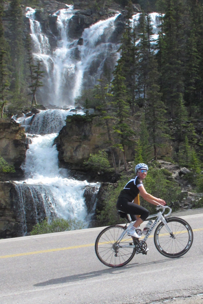
Tangle Falls:
As you climb up the side of this beauty on your way up to the Columbia Icefields you’ll be stopped in your tracks by one of the most commonly photographed waterfalls along the Icefields Parkway, Tangle Falls. Flowing from Tangle Creek the falls cascade 48m (159ft) down a broad cliff before consolidating and dropping over three more consecutive tiers of 14, 18 and 13 feet respectively, then funnelling under the Icefields Parkway via a culvert. The falls are a very popular study for professional photographers and during the day tourists are commonly seen flocking at the bottom of the falls for a quick photo op. They’ll take a break from gazing at the falls and cheer you on as you climb onwards and upwards. You can do it, Just 1km to go on the big bump till you’re rewarded with a downhill and flatter terrain.


Stutfield Glacier, Stutfield Peak 3450m (11320ft) (1899), explorers
After enjoying the views of Tangle Peak and the rare flat terrain that proceeds the big bump you’ll start the main challenge of the day, the 3km long Big Bump. Don’t worry though less than 1km into the climb you’ll come across the Stutfield Glacier viewpoint. The Stutfield Glacier features a picturesque pair of ice falls which spill 914m (3000ft) down the face of Mount Stutfield. We’ll be waiting for you there for a photo and some encouragement. You can rest up here and take in the view or if you’re struggling jump in the van for a cheeky shuttle to the top.
The glacier and a mountain by the same name, were named by J Norman Collie after his friend and climbing partner Hugh Stutfield. Together, they wrote Climbs and Exploration of the Canadian Rockies.


Mount Kitchener 3505m (11500ft.) (1916), WWI / Kitchener Glacier
You’ll get a preview of this bad boy from the first rest stop on day two of the tour at the Mushroom and Diadem peaks view point. Its the huge cliff face capped with a thick layer of Ice and snow to the right of Tangle Peak. Mid way through the big bump shortly after passing the Stutfield Glacier viewpoint, don’t forget to look right as Mount Kitchener presents itself in a most spectacular fashion. Although its southwestern slopes are very gentle as the Columbia Icefield drapes itself from the summit, the near-vertical cliffs on the highway side looms impressively above you as you tackle the big bump.
Norman Collie named this mountain Mount Douglas after the well known botanist David Douglas, for which the Douglas Fir is named. The name was changed to Mount Kitchener in 1916 to honour British Field Marshall Horatio Kitchener who had recently died when HMS Hampshire hit a mine. Collie may not have been aware that Mount Douglas in the upper Red Deer Valley had been named after David Douglas in 1884.
The first ascent of Mount Kitchener was completed by Alfred J. Ostheimer and Hans Fuhrer during an impressive 36 hour outing from their base at the head of the Athabasca Valley. As well as climbing Mount Kitchener, they completed the first ascent of Stutfield Peak and climbed North Twin Peak and Snow Dome. They reached the summit of Kitchener at 2:00 am.


Wilcox Peak, 2884m (9462ft.) (1924) explorer
After conquering the big bump there’s a short sharp down hill followed by some rocky mountain flats (slightly uphill) heading toward the Columbia Icefields centre where we’ll have lunch. There will likely be a cool headwind blowing down the valley from Athabasca Glacier but don’t let that get you down. Instead look around at your marvellous surroundings. To the left you’ll see an intimidating scree slope littered with large boulders that have slid down the side of Wilcox Peak. In winter this is prime avalanche territory and even in summer you don’t want to linger here too long just in case a piece of the mountain decides to let go.
Mount Wilcox, along with the creek and pass, was named after Walter Wilcox, a Yale-educated explorer who wrote an early guide book titled The Rockies of Canada, first published in 1896 and final edition published in 1909. He is credited for accomplishing first ascent (1896) of the peak that bears his name.
The official name of the mountain is Wilcox Peak but there is some confusion about this. The name Wilcox Peak was suggested by Norman Collie in 1899 and it was officially approved by the Geographic Board of Canada in 1924. In 1928 it was changed to Mount Wilcox but officially changed back again to Wilcox Peak in 1956. This back and forth-ing likely explains the confusion.


Snow Dome 3456m (11339ft.)
From the Lunch stop at the Columbia Icefields centre you’ll be surrounded by impressive peaks in all directions, most of which will be covered in the following blog posts. To your right side the 30m thick Dome glacier descends from Snow Dome Mountain, whose summit is entirely covered by the Columbia Icefield. Although most tourists come to see the more famous Athabasca Glacier to the left of Dome Glacier, I personally think this ones much more spectacular.
The mountain was named by J Norman Collie in 1898, who along with his partners, achieved first ascent about the time of naming. It is located on the continental divide between Dome and Athabasca Glaciers.
Norman Collie named the mountain “The Dome” in 1898. In 1919 the name was modified to “Snow Dome.”
The day after climbing Mount Athabasca, Norman Collie and his party ascended the right side of the Athabasca Glacier and bivouaced for the night. Setting off at 1:30 the next morning they headed for the chisel shaped, glacier draped mountain (Mount Columbia) they had seen towering above the opposite side of the icefield. At noon, when they seemed no closer to their goal, they turned back, more aware now of the size of the icefield they had discovered.
Collie and Hugh Stutfield later wrote, “To the eastward of where we stood, and almost on our way home, rose a great white dome, and we determined to ascend it. After a hot and very tiring climb through snow that broke under our feet at every step, we finally reached the summit at 3:15. We have named this peak The Dome.”
Snow Dome is a remarkable peak in a number of ways. First, it’s considered to be North America’s hydrological apex, a point where three different watersheds meet. Water from the top of Snow Dome can flow in three directions, ending up in either the Pacific ocean via the Columbia River, Atlantic ocean via the Saskatchewan and Nelson Rivers or the Arctic Ocean via the Athabasca, and eventually the Mackenzie.
It’s also unique in that it sits on the border between Alberta and British Columbia, and also straddles the border that separates Banff and Jasper National Parks.


Mount Columbia 3747m (12294ft.) (1898), explorers
Although you can’t see Mount Columbia from the vantage point of the Lunch stop at the Columbia Icefields visitors centre we thought we’d include it because it’s the highest point in Alberta and second only to Mount Robson in the Canadian Rockies. Mount Columbia lies on the northern edge of the Columbia Icefield, 9.7 km southwest of Snow Dome.
J Norman Collie named this peak after the Columbia River which was named after the ship captained by Robert Tray who first ventured over a dangerous sandbar and explored the lower reaches of the river.
Approaching the mountain from the Columbia Icefield, James Outram, together with guide Christian Kaufmann, made the first ascent of Mount Columbia in 1902.
Columbia Icefield
The Columbia Icefield is a surviving remnant of the thick ice mass that once mantled most of Western Canada’s mountains. Lying on a wide, elevated plateau, it is the largest icefield in the Canadian Rockies. Nearly three-quarters of the park’s highest peaks are located close to the icefield; ideally placed to catch much of the moisture that Pacific winds carry across the British Columbia interior.
Since more snow falls in a year than can melt during the short summer season, it accumulates. As time passes, the snow transforms into ice and begins to flow outward through gaps in the mountains surrounding the icefield, creating great tongues of ice called glaciers.
Stretching 325 sq km (125 sq mi) across the Continental Divide, this extensive field of ice feeds six major glaciers, reaches an estimated depth of 365 m (1,299 ft) and receives up to 7m of snowfall a year.
The Columbia Icefield feeds the Columbia, Mackenzie and Saskatchewan rivers, and its meltwaters flow into the Pacific, Arctic and Atlantic oceans. It is one of only two hydrological apexes in the world that feeds three oceans.
The Columbia Icefield was one of the last major geological features to be discovered by man in western Canada, due to its isolation and harsh weather conditions. In April 1827, Scottish botanist David Douglas was crossing Athabasca Pass—a major trading route located north of the Icefield—when he climbed one of the adjacent mountain peaks. He reported his first ascent in his journal, describing it to be 6,000 metres (20,000 ft) in height. In the summer of 1884, geology professor Arthur Philemon Coleman explored the Great Divide from Banff to Jasper in search of Douglas’ giant peak. While unsuccessful, he did discover the route that would become the Icefield Parkway. In July 1898, British explorer J. Norman Collie and his friends Hugh Stutfield and Herman Wooley set off in search of Douglas’ giants, equipped by the famous Banff outfitter Bill Peyto. On the morning of August 18, Collie and Wooley climbed the east side of Mount Athabasca, moved up the glacier when the ridge gave way to crumbling rock, and made their way to the summit, where they discovered an ice field that extended to almost every horizon.
Collie later wrote:The view that lay before us in the evening light was one that does not often fall to the lot of modern mountaineers. A new world was spread at our feet: to the westward stretched a vast ice-field probably never before seen by the human eye, and surrounded by entirely unknown, unnamed and unclimbed peaks.

Athabasca Glacier:
To the left of Dome Glacier is one of the most visited Glaciers in North America.
Approximately 6 km (3.7 mi) long, surrounded by high mountain peaks it covers an area of 6 km2 (2.3 sq mi), and is measured to be between 90–300 metres (300–980 ft) thick.
Its ice is in continuous motion, creeping forward at the rate of several centimeters per day. Spilling from the Columbia Icefield over three giant bedrock steps, the glacier flows down the valley like a frozen, slow-moving river.
When Walter Wilcox’s party reached Sunwapta Pass in 1896 the Little Ice Age was ending but Athabasca Glacier still extended to where the Icefields Parkway is today and was as high as the tops of the lateral moraines we see on either side of the valley.
Because of a warming climate, the Athabasca Glacier has been receding or melting for the last 125 years currently receding at the rate of about 5cm per year. Losing half its volume and retreating more than 1.5 kms, the shrinking glacier has left a moonscape of rocky moraines in its wake.


Mt Andromeda 3450m (11319ft.)
As you ride across the flats towards The Columbia Icefields visitors centre and the Lunch stop for today the majority of your view will be taken up by Mt Andromeda to the right and Mt Athabasca to the left (Described below) .
Located between Athabasca Glacier and Saskatchewan Glacier. on the border of Banff & Jasper parks it was named by Rex Gibson (a former president of the Alpine Club of Canada) in 1938.
In Greek mythology Andromeda was the wife of Perseus who rescued her from a sea monster. It is also the name of the nearest galaxy to our Milky Way. The Andromeda Galaxy can easily be seen with binoculars.

Mount Athabasca 3491m (11454ft.)
The outstanding, glacier draped peak to the left of Athabasca Glacier and Mount Andromeda is Mount Athabasca. One of the classic peaks of the Canadian Rockies, practically the entire mountain is above the tree line.
Mount Athabasca was named in 1898 by J Norman Collie. Athabasca is the Cree Indian name for “where there are reeds” and originally referred to Lake Athabasca. The Athabasca river and its tributaries were an important travel route in fur trade days.
In 1898 Sunwapta Pass was visited by Norman Collie, Herman Woolley, and Hugh Stutfield. They too were most impressed with Mount Athabasca, Stutfield and Collie later writing, “Immediately opposite our camp, to the south-west, rose a noble snow-crowned peak, about 12,000 feet in height, with splendid rock precipices and hanging glaciers; and on its right the tongue of a fine glacier descended in serpentine sinuosities to the bottom of the valley. We named them Athabasca Peak and Glacier respectively. The spirits of us three climbers rose high, and our blood was stirred within us at the thought of being once more on the ice and snow…It was decided, therefore, that we should attack the peak next day.
On August 18, 1898, Norman Collie and Hermann Woolley became the first to grasp the extent and significance of the Columbia Icefield when they completed the first ascent of Mount Athabasca, the spectacular peak to the east of the Icefield and just south of Athabasca Glacier. Collie’s description of the view from the summit is classic Canadian Rockies literature and it is a testament to his intelligence that he understood the geographical significance of what he saw. “The view that lay before us in the evening light was one that does not often fall to the lot of modern mountaineers. A new world was spread at our feet; to the westward stretched a vast ice-field probably never before seen by human eye, and surrounded by entirely unknown, un-named, and unclimbed peaks. From its vast expanse of snows, the Saskatchewan Glacier takes its rise, and it also supplies the headwaters of the Athabasca; while far away to the west, bending over in those unknown valleys glowing with evening light, the level snows stretched, to finally melt and flow down more than one channel into the Columbia River, and thence to the Pacific Ocean.”
What Collie and Woolley had the pleasure of discovering was the largest icefield in Canadian Rockies, encircled by a most spectacular collection of nine high peaks (Stutfield Peak, North Twin Peak, South Twin Peak, Mount King Edward, Mount Columbia, Mount Bryce, Mount Athabasca, Mount Andromeda, Snow Dome and Mount Kitchener). Together with Hugh Stutfield, who had offered to go hunting that day to restock their larder, they named seven of them.
Hilda Peak 3058m (10,033ft)
After cycling over Sunwapta Pass and 4km into the downhill section you’ll come across the Parker Ridge pull out. Make sure you pause here for a minuite and look behind you for an awesome view. One can’t help but be taken aback by the striking view of the wedge-shaped Hilda Peak on the right, whose sharp summit thrusts over the parkway while the back side of giant Mt. Athabasca looms behind and to the left.
From Parkers Ridge there is a 2hr, 6km round trip hike if you have time which gives amazing views of the Saskatchewan Glacier.
The largest glacier on the Columbia Icefield, the Saskatchewan Glacier is roughly 13 km (8 mi) long and covers an area of 30 sq km (11.5 sq mi).


Nigel Peak and Pass 3211m (10535ft.) (1898), explorer
Nigel Peak is a high, three km long ridge that forms the boundary between Banff and Jasper National Parks to the northeast and north of Sunwapta Pass. The northwest summit is the highest point but the southeast summit is very prominent as the Columbia Icefield area is approached on the Icefields Parkway. You’ll notice the Northwest summit above the Columbia Icefields centre during lunch and ride under the towering South east summit on your way up and over Sunwapta Pass.
Named by J Norman Collie after one of Collie’s packers, Nigel Vavasour. Stutfield, Bill Peyto and Vavasour had been sent to hunt bighorn sheep to replenish the party’s meat supplies while Collie and Woolley attempted to summit Athabasca Peak. The eventful hunt took place in the vicinity of Nigel Peak.
Nigel Vavasour was a packer who accompanied Norman Collie and Hugh Stutfield to the Columbia Icefield area in 1897. Collie wrote, “We gave them another hour and then followed them up an open valley, towards a lake that lay at the foot of a high snow-clad peak of which Nigel is now the eponymous hero.”
In 1944, Nigel Peak was the scene of an avalanche fatality. The “Lovat Scouts” was a Scottish military unit which spent three months training in mountain warfare techniques in the Canadian Rockies. Five hundred men were involved and the unit was to be a critical component of a possible invasion of Norway’s mountainous terrain which was at that time occupied by enemy forces.
The chalet at the Columbia Icefields was used as a training base and on January 19th, a party of twelve guided by Sgt. Peyto of the Canadian army (the son of legendary outfitter Bill Peyto) set off for Nigel Peak. It was a bright, warm day and as the party approached the summit on mountain’s south slopes an avalanche carried the entire group down towards Wilcox Pass. As they prepared to descend to safer ground, a second avalanche broke loose but missed the party. Then, as they were nearing the valley below a “huge” avalanche came down burying L/Cpl. Sandy Collie and Cpl Angus Cameron. Cpl. Cameron’s hand was left uncovered and he was rescued but L/Cpl. Collie was buried under four to five feet of snow and did not survive.

